Hurricane Isaias Strengthens to Category 3 as Gulf Coast Braces for Devastating Impact
Powerful winds, dangerous storm surge and widespread flooding threaten coastal communities as Georgia and other southeastern states prepare for the hurricane’s arrival.
By A.T.L. N.E.W.S. Staff | October 9, 2026
NATIONAL NEWS | WEATHER
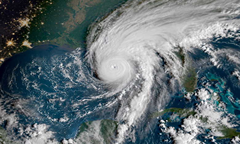
GULF COAST — Millions of Americans across the southeastern United States are preparing for potentially catastrophic weather as Hurricane Isaias approaches the northern Gulf Coast, threatening coastal communities with destructive winds, life-threatening storm surge and widespread flooding.
The hurricane intensified into a Category 3 storm Friday morning, October 9, with maximum sustained winds reaching 120 mph, according to the National Hurricane Center. At 11 a.m. Central Time, Isaias was located approximately 180 miles south of Pensacola, Florida, moving north-northeast at 16 mph.
Forecasters expect the hurricane to make landfall along the Alabama-Florida coast Friday night or early Saturday. Florida, Alabama and Mississippi have declared states of emergency as officials coordinate evacuations, establish emergency shelters and prepare response teams for what could become one of the region’s most destructive weather events in recent years.
Florida Panhandle and Alabama Face Greatest Threat
Communities from Mobile Bay to the western Florida Panhandle are expected to experience some of Isaias’ most dangerous conditions. Forecasters warn that hurricane-force winds could cause extensive damage to homes, businesses, electrical infrastructure and transportation networks.
Storm surge remains one of the greatest threats. Water levels could rise as much as 9 feet above normally dry ground in some vulnerable coastal areas, potentially flooding neighborhoods and making evacuation routes impassable.
Mandatory evacuations have been ordered in several coastal communities, while residents in other threatened areas have been encouraged to complete storm preparations before conditions deteriorate.
The hurricane is also expected to bring widespread rainfall totals of 4 to 8 inches across parts of the Southeast, with isolated areas potentially receiving up to 15 inches. Such rainfall could trigger flash flooding, river flooding and dangerous conditions well beyond the immediate landfall area.
Georgia Prepares for Heavy Rain and Potential Flooding
Although Isaias is expected to make landfall west of Georgia, the Peach State could experience significant effects as the hurricane moves inland.
Georgia Gov. Brian Kemp has declared a state of emergency as authorities prepare for heavy rainfall, potentially damaging winds and flooding across portions of the state.
Southwest Georgia faces the possibility of particularly heavy rainfall as the storm’s circulation moves inland. Communities across central and northern Georgia could also experience gusty winds, periods of heavy rain and localized flooding.
In metropolitan Atlanta, residents should monitor forecasts for possible travel disruptions, flooded roadways and downed trees. Areas near creeks, streams and low-lying roadways could become especially vulnerable during prolonged rainfall.
Emergency management officials are encouraging residents to secure outdoor belongings, charge mobile devices, prepare emergency supplies and remain alert for changing weather conditions throughout the weekend.
Hurricane Threatens Regional Travel and Energy Operations
The approaching storm has already disrupted transportation and energy operations across the Gulf Coast.
Airlines and transportation providers are adjusting services in anticipation of dangerous weather, while coastal airports and highway networks could face additional disruptions as Isaias moves ashore.
Energy companies have also reduced operations at offshore oil and natural gas facilities, removing personnel from threatened platforms and temporarily suspending production.
Extended disruptions to Gulf Coast energy infrastructure could create additional pressure on fuel supplies and transportation costs, although the ultimate economic impact will depend on the severity of storm damage and the duration of facility closures.
An Unusually Quiet Hurricane Season Takes a Dangerous Turn
Isaias marks a dramatic shift in what has been an unusually quiet Atlantic hurricane season.
The 2026 season has been influenced by a strong El Niño pattern, which typically generates upper-level winds that can disrupt tropical cyclone development.
However, exceptionally warm Gulf waters helped fuel Isaias’ rapid intensification. Scientists say warm ocean temperatures provide additional energy to tropical systems, potentially allowing storms to strengthen quickly when atmospheric conditions become favorable.
The hurricane developed into the season’s first major hurricane despite the atmospheric conditions that had limited tropical activity earlier in the year.
Federal and State Emergency Agencies Mobilize
The Federal Emergency Management Agency and state emergency management officials are coordinating preparations for hurricane response and recovery.
Emergency personnel, equipment and supplies have been positioned in threatened areas as officials prepare for possible flooding, widespread electrical outages and damage to homes and businesses.
The response will also test emergency management resources at a time when FEMA has faced scrutiny over staffing reductions and organizational changes.
Officials emphasize that residents should follow instructions from local authorities rather than relying solely on the hurricane’s projected path. Dangerous winds, flooding and tornadoes can occur far from the center of a tropical cyclone.
What Residents Should Do Before Isaias Arrives
Residents in threatened communities should complete emergency preparations and immediately follow any mandatory evacuation orders issued by local authorities.
Households should have access to drinking water, nonperishable food, medications, flashlights, batteries and fully charged communication devices. Those using portable generators should operate them outdoors, away from windows and doors, to prevent carbon monoxide poisoning.
Motorists should never attempt to drive through flooded roads, even when water appears shallow. Floodwaters can conceal washed-out pavement, strong currents and other hazards.
Residents can obtain the latest official storm information from the National Hurricane Center at https://www.nhc.noaa.gov/ and local National Weather Service offices.
A Dangerous Weekend Ahead
As Hurricane Isaias approaches the Gulf Coast, emergency officials are warning that its effects could extend well beyond the communities experiencing the strongest winds.
Heavy rainfall, flooding, tornadoes and power outages could affect several states as the system travels inland during the weekend.
For communities in the storm’s projected path, officials stress that preparation and compliance with emergency instructions could make the difference between safety and tragedy.
A.T.L. N.E.W.S. will continue monitoring Hurricane Isaias, including its impact on Georgia and communities throughout the southeastern United States.
Developing Story | Information based on National Hurricane Center advisories and reporting available October 9, 2026. Storm conditions and forecasts are subject to change.